Whether you’re chasing bass, redfish or salmon this fall, chances are you’ll rely on some form of digital navigation before making the first cast. However, navigating regulations can be trickier than using your fish finder or mapping app. Federal agencies including NOAA, the Department of the Interior, U.S. Forest Service and U.S. Army Corps of Engineers maintain information on fishing and boating access and restrictions in different formats and across different systems.
Fragmented information makes it harder for mapping tools to show anglers and boaters where they can launch, where they can fish and what restrictions apply. Making that information consistently available in usable digital formats would help people plan their trips with greater certainty.
Federal lands and waters are a major part of where Americans fish and boat. In fiscal year 2024, federal agencies reported approximately 73.5 million fishing visits and 83.5 million boating visits, underscoring how many outings depend on access to these places and reliable information about them.
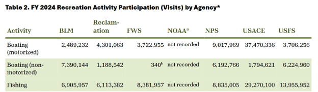
Source: Federal Interagency Council on Outdoor Recreation, FY 2024 Interagency Recreation Visitation Data Report, June 2026, Table 2, p. 3.
Fortunately, a series of bills passed by Congress is helping to modernize federal mapping data, making it easier for anglers and boaters to confidently get out on the water.
Last week, the House passed the Modernizing Access to Our Public Oceans (MAPOceans) Act (S. 759), sending the legislation to the President’s desk. Introduced by Senators Ted Cruz (R-TX) and Angus King (I-ME), and in the House by Reps. Russell Fry (R-SC) and Mike Levin (D-CA), this ASA priority legislation had already passed the Senate last September.
The MAPOceans Act directs NOAA to standardize, digitize and make publicly available information on federally managed marine waters and fisheries. The legislation also ensures that federal data can support timely updates when regulations change.
MAPOceans builds on recent mapping legislation on inland waters. Last December, the Modernizing Access to Our Public Waters (MAPWaters) Act (H.R. 187) was signed into law. The bipartisan legislation, led in the House by Reps. Blake Moore (R-UT) and Jimmy Panetta (D-CA), and in the Senate by Sens. John Barrasso (R-WY.) and Angus King (I-ME), requires the Department of the Interior and U.S. Forest Service to standardize and digitize recreation information for federally managed reservoirs, lakes and rivers. Together, MAPWaters and MAPOceans will improve digital access to information including:
- Watercraft type, horsepower and motor restrictions;
- Closures and the status of access points such as boat ramps and fishing access sites;
- Fishing restrictions, including restrictions on equipment, bait and methods of fishing; and
- Navigation information, including water depths and underwater terrain.
The information also needs to work together across agency boundaries. MAPWaters requires Interior and the Forest Service to develop interagency data standards to ensure their databases are interoperable; MAPOceans similarly directs NOAA to coordinate with these federal land management agencies to ensure compatible formatting. That standardization will make it easier for companies operating fish finders, chartplotters and mapping platforms to incorporate and update federal information into the tools anglers and boaters already use.
However, one major piece remains: US Army Corps of Engineers-managed waters. The Corps is one of the largest providers of outdoor recreation in the country, welcoming approximately 260 million visits each year at more than 400 lake and river projects in 43 states – including top destinations like Table Rock Lake and Lake Lanier.
Congress has already taken a first step toward improving Corps recreation information. Section 1121 of the Water Resources Development Act (WRDA) of 2024 requires the Corps to regularly update publicly available databases with information on the operational status of its recreation sites and the recreational opportunities available at those sites. While a positive starting point, Section 1121 did not go as far as MAPWaters and MAPOceans in ensuring that Corps information is standardized and compatible with recreation data maintained by other federal agencies.
The 2026 WRDA bill provides an opportunity to take the next step. As the House and Senate advance their respective WRDA packages, ASA and partners are highlighting Section 1116 in the Senate version, which would build on the 2024 provision by directing the Corps to ensure its recreation data is consistent and compatible with data published by Interior agencies, the Forest Service and NOAA.
ASA, the Corps Foundation, the Theodore Roosevelt Conservation Partnership, National Marine Manufacturers Association and RV Industry Association recently wrote to House Transportation and Infrastructure Committee and Senate Environment and Public Works Committee leadership encouraging inclusion of the Senate provision in the final WRDA agreement.
Including Section 1116 would help bring information on Corps-managed lakes and waterways into the broader federal data framework established through MAPWaters and MAPOceans, making that information easier for technology providers and the recreating public to use.
As high-performing navigation tools become increasingly commonplace on the water, the federal information behind those tools needs to keep pace. Standardized, compatible and up-to-date data can reduce confusion over access and regulations and help anglers spend more time fishing. ASA commends Congress and the bipartisan sponsors of MAPWaters and MAPOceans for advancing these commonsense improvements and encourages House and Senate negotiators to include Section 1116 of the Senate WRDA bill in the final Water Resources Development Act of 2026.
Share This Article, Choose Your Platform:
Recent Posts

AUTHOR
Connor Bevan
Inland Fisheries Policy Manager